
Description
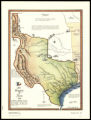
This colorful map shows the early boundaries of the Republic of Texas in 1836. Rivers, mountains, and emigration trails are shown. The Santa Fe Trail is on the map along with illustrations of settlers traveling along it in covered wagons. In the center, Native Americans (the Comanches were near this area) are chasing buffalo. The text details the boundaries of Texas and the Declaration of Independence from Mexico. During James K. Polk's presidency, the nation expanded significantly with the annexation of the Republic of Texas.During the presidential election of 1844, the annexation of Texas and the expansion of slavery was a major issue. The Whig Party nominee, Henry Clay, adopted an anti-annexation platform on the principle of preserving the North-South sectional unity and to avoid war by respecting Mexico's claims to Texas. The Democrats nominated James K. Polk who ran on a platform that embraced America's popular commitment to territorial expansion, often referred to as Manifest Destiny. During the presidential campaign, Polk successfully linked the United States-British boundary dispute over the partition of Oregon Territory with the Texas annexation debate. By doing so, Polk united the anti-slavery Northern expansionists, who demanded Oregon as free from slavery with pro-slavery Southern expansionists, who insisted on acquiring Texas as a slave state. After a hard fought campaign, James K. Polk was elected as the eleventh president of the United States. Eventually, Texas was annexed and became part of the United States on December 29, 1845.
Image
Maps
Record Contributed By
Tennessee State Library & ArchivesRecord Harvested From
Digital Library of TennesseeKeywords
- Buffaloes
- Cities & Towns
- Colorado River (Colo. Mexico)
- Covered Wagons
- History
- Maps
- Old San Antonio Road (Tex. Alamo (San Antonio, Tex. Mexico, Gulf Of
- Republic, 1836 1846
- Rio Grande (Colo. Mexico And Texas)
- Rivers
- Roads
- Sailing Ships
- Santa Fe National Historic Trail
- Texas
- Trails
Related Content


![Letter from William Lloyd Garrison, Brooklyn, [Conn.], to Henry Clarke Wright, April 11, 1836](https://d2l9jrtx1kk04i.cloudfront.net/0115e9f559c86526cffc9b4294c0f2a55e2e4af2.png "Letter from William Lloyd Garrison, Brooklyn, [Conn.], to Henry Clarke Wright, April 11, 1836")
![Copy of letter from William Lloyd Garrison, Boston, [Mass.], to John Farmer, June 6, 1837](https://d2l9jrtx1kk04i.cloudfront.net/0a058676eb6ff11ef69f402d9aec25869ba1350b.png "Copy of letter from William Lloyd Garrison, Boston, [Mass.], to John Farmer, June 6, 1837")
![Letter from William Lloyd Garrison, Boston, [Mass.], to George William Benson, June 14, 1837](https://d2l9jrtx1kk04i.cloudfront.net/450883e2f31ba14b29ba0d141d0fc76872a015ba.png "Letter from William Lloyd Garrison, Boston, [Mass.], to George William Benson, June 14, 1837")