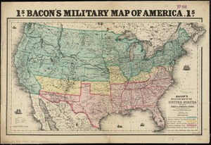
Bacon's military map of the United States shewing the forts & fortifications
View
@ Boston Public Library

Bacon & Co
Description
Relief shown by hachures.Prime meridians: Washington and Greenwich.Shows free or non-slavehold states, border slave states, and seeded or confederate states.Includes population and land area figures."Ent. Sta. Hall. Aug. 1862."
Image
Maps
No known copyright restrictions.No known restrictions on use.


