G. Woolworth Colton's map of the country 500 miles around Cairo
View
@ Lionel Pincus and Princess Firyal Map Division. The New York Public Library

Description
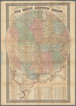
Circular map centered on Cairo, Ill., with five concentric circles at intervals of 100 miles. Circle has extension of 4 cm at bottom, to include all of southeastern Louisiana.Main circular map appears to be covering a larger scale map of Illinois and Indiana, of which the southern counties, along with adjacent parts of Missouri, Kentucky, and Ohio, are visible at the scale of 1:1,267,200.Includes a list of the "Principal forts and military stations in the Western and Gulf states" and list of river distances.
Text
Maps
Colton, G. Woolworth (George Woolworth), 1827-1901
1861


![Where the Civil War began--Fort Sumter, and distant mainland to right, S.C. [Active no 5669 : interpositive.]](https://d2l9jrtx1kk04i.cloudfront.net/5bca1fda25d9273856349294e0400f8949b96fe8.png "Where the Civil War began--Fort Sumter, and distant mainland to right, S.C. [Active no 5669 : interpositive.]")
