
Description
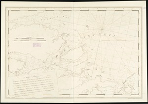
Chart of the southeast coast of Nova Scotia from "Buller Bay" (Jordan Bay) to Cape Negro Island.Oriented with north toward the upper left.Appears in the author's Atlantic Neptune. London : J.F.W. Des Barres, 1777-[1781].
Image
Maps
No known copyright restrictions.No known restrictions on use.
Record Contributed By
Boston Public LibraryRecord Harvested From
Digital CommonwealthKeywords
- Coasts
- Early Works To 1800
- Maps
- Nautical Charts
- Nova Scotia
- Shelburne Harbor
- Shelburne Harbor (N.S.)
Related Content


![Portolan chart], [1516](https://d2l9jrtx1kk04i.cloudfront.net/15d9ab8fddeae943826cc533259ee21e4245a192.png "Portolan chart], [1516")
")


![Map of New-York Bay and Harbor and the environs : [with colored manuscript additions to show positions of troops and fleets at the Battle of Long Island, 1776]](https://d2l9jrtx1kk04i.cloudfront.net/861b59bb0ac04500efd22c07eb61e9424fa0dae6.png "Map of New-York Bay and Harbor and the environs : [with colored manuscript additions to show positions of troops and fleets at the Battle of Long Island, 1776]")
