
Description
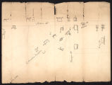
Hand-drawn map of Franklin accompanying the 1850 Supreme Court case file of Henry, a slave v. State of Tennessee. The map exhibit details the area where Main Street and Columbia Turnpike intersect. Many churches, businesses, and homes are depicted as are the locations that the bodies of Barham and Eelbeck were found. The Presbyterian Church, an Episcopal Church [St. Paul's], female institute [Franklin Female Institute], and a male academy [Harpeth Academy] are all denoted. Businesses include Boyd's Store, McGan's shop, and a tanyard. Homeowners include Hannah Henderson [where the local enslaved population held prayer meetings], Baugh, Betsy Wills, McGan, Wells, Courtney, McConnell, Park, Dr. Ewing, Bennett, Bridge, and Harrison.Henry, enslaved by John D. Bennett, was accused of the murders of John G. Eelbeck and William Barham on the night of February 24, 1850. Eelbeck was stabbed in the left breast with a knife and sustained a wound two inches wide, and three inches deep. After a grand jury indictment, Henry, through court appointed attorneys, pled not guilty. On November 26, 1850, the jury found Henry guilty and sentenced him to be hanged on December 14. During testimony, Dr. A. B. Ewing described Eelbeck as a 22 year old white male, weighing about 120 pounds. Ewing and other witnesses described Henry as stout and sporting a long goatee. Witnesses mentioned seeing Henry with a butcher knife earlier in the day, some identified Henry as the murderer, while others refused to identify him as such. Another man, William P. Barham, was killed...
Image
Maps
Record Contributed By
Tennessee State Library & ArchivesRecord Harvested From
Digital Library of TennesseeKeywords
- Churches
- Dwellings
- Franklin (Tenn.)
- Homicides
- Judicial Proceedings
- Maps
- Maps, Manuscript
- Tennessee. Supreme Court
Related Content
")
")
")
")


")
")
")
")
")
")