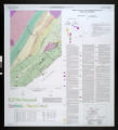
Bedrock geology of the Schroeder quadrangle, Cook County, Minnesota, M-170
View
@ Minnesota Geological Survey

Boerboom, Terrence J.; Green, John C
Description
Interpretations of bedrock geology (distribution of rock at the land surface and beneath surface sediments) of the Schroeder quadrangle, scale 1:24,000. Electronic file available at: ftp://mgsftp2.mngs.umn.edu/map_catalog/pdf/umn22588.pdf
Image
Maps
Public domain. We request that if the images are used credit be given to the Minnesota Geological Survey, University of Minnesota.


![Executive documents, printed for the General Assembly of North Carolina, at the session of ...[1852] N.C. public documents](https://d2l9jrtx1kk04i.cloudfront.net/7d150a533bbb534d98c8a91d1cbbcdfc4a830806.png "Executive documents, printed for the General Assembly of North Carolina, at the session of ...[1852] N.C. public documents")
, Shawnee County, Kansas")
![Legislative documents :session ...[1854, 1855]](https://d2l9jrtx1kk04i.cloudfront.net/f42129779ed4bd9479225603b607ccfb0f250128.png "Legislative documents :session ...[1854, 1855]")
![Executive and Legislative documents laid before the General Assembly of North-Carolina [1868; 1869]](https://d2l9jrtx1kk04i.cloudfront.net/1a6a526db2036bd358ea0d91d827c889682f2081.png "Executive and Legislative documents laid before the General Assembly of North-Carolina [1868; 1869]")
![Antelope Spring [03]](https://d2l9jrtx1kk04i.cloudfront.net/d33d2511cbd01ab4f0f4ee23b72923b435bcf87c.png "Antelope Spring [03]")

