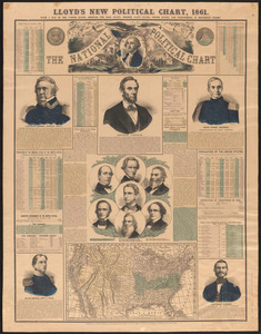
Lloyd's new political chart, 1861 with a map of the United States, showing the free states, border slave states, cotton states, and territories, in different colors
View
@ Boston Public Library

H.H. Lloyd & Co
Description
Compiled and published by H.H. Lloyd & Co. Hand-colored lithograph composed of map, wood-cut portraits, biographies and statistics. Includes portraits of political figures and biographies of Lincoln and his cabinet Lieutenant-General Winfield Scott, Major Robert Anderson, Major-General John Wool and Lieutenant Slemmer (commanding Fort Pickens). The statistics include census information for major cities, electoral results for every election from 1796 and popular vote data by state for the election of 1860.
Text
Maps Posters
No known copyright restrictions.No known restrictions on use.


![Letter from Charles Augustus Stackpole, Portland, [Maine], to William Lloyd Garrison, 1864 June 6th](https://d2l9jrtx1kk04i.cloudfront.net/a296ec8b576514612d8e528627a52c7a3f0fbd7a.png "Letter from Charles Augustus Stackpole, Portland, [Maine], to William Lloyd Garrison, 1864 June 6th")

![Letter from Henry Clarke Wright, Florence, [Massachusetts], to William Lloyd Garrison, [18]64 June 25](https://d2l9jrtx1kk04i.cloudfront.net/4badcc2e3f6e75d7ec5e81892e28fa100cfdfddb.png "Letter from Henry Clarke Wright, Florence, [Massachusetts], to William Lloyd Garrison, [18]64 June 25")
![Letter from Oliver Johnson, New York, [N.Y.], to William Lloyd Garrison, 28 May, 1864](https://d2l9jrtx1kk04i.cloudfront.net/6093475b283394130126febc0afb2a2283d14dfc.png "Letter from Oliver Johnson, New York, [N.Y.], to William Lloyd Garrison, 28 May, 1864")
![Letter from Alfred Harry Love, Philad[elphi]a, [Pa.], to William Lloyd Garrison, [August] 13th 1864](https://d2l9jrtx1kk04i.cloudfront.net/482c616e916bee65c2a3d01a5b8910adbf77ad66.png "Letter from Alfred Harry Love, Philad[elphi]a, [Pa.], to William Lloyd Garrison, [August] 13th 1864")
![Letter from Harriet Martineau, Ambleside, [England], to William Lloyd Garrison, August 10 / [18]64](https://d2l9jrtx1kk04i.cloudfront.net/0b249b2e8295a7a342d9645723e91b8001820c96.png "Letter from Harriet Martineau, Ambleside, [England], to William Lloyd Garrison, August 10 / [18]64")
![Letter from Alfred Harry Love, Philade[elphi]a, [Pa.], to William Lloyd Garrison, [March] 10. 1864](https://d2l9jrtx1kk04i.cloudfront.net/c647852987f72ef5632b202cd8215e3b6dc3df3e.png "Letter from Alfred Harry Love, Philade[elphi]a, [Pa.], to William Lloyd Garrison, [March] 10. 1864")
![Letter from Elizabeth Pease Nichol, Edinburgh [Scotland], to William Lloyd Garrison, Sep[tembe]r 23, 1864](https://d2l9jrtx1kk04i.cloudfront.net/9abede82d17cd41b4634b7ad01c761ffea564054.png "Letter from Elizabeth Pease Nichol, Edinburgh [Scotland], to William Lloyd Garrison, Sep[tembe]r 23, 1864")
![Letter from Aaron Macy Powell, Worcester, [Mass.], to William Lloyd Garrison, May 17, 1864](https://d2l9jrtx1kk04i.cloudfront.net/ea0c557e12628ce0d0585614b3386516d9141ffb.png "Letter from Aaron Macy Powell, Worcester, [Mass.], to William Lloyd Garrison, May 17, 1864")
![Letter from Elizabeth Cady Stanton, New York, [New York], to William Lloyd Garrison, 1864 April 22](https://d2l9jrtx1kk04i.cloudfront.net/724c8e9f26750aa8ec0e08ce796338b1d1a689ef.png "Letter from Elizabeth Cady Stanton, New York, [New York], to William Lloyd Garrison, 1864 April 22")
![Letter from Gerrit Smith, [Peterboro, N.Y. ?], to William Lloyd Garrison, Oct[ober] 10 1864](https://d2l9jrtx1kk04i.cloudfront.net/6933e793f67f6c0810889a014e2a23058a6e409a.png "Letter from Gerrit Smith, [Peterboro, N.Y. ?], to William Lloyd Garrison, Oct[ober] 10 1864")


 1983 September 28")
, 1984 April 26")