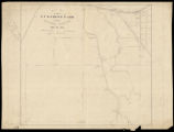
Map of the Z. T. Watkins farm at Ooltewah Junction, James Co., Tenn.
View
@ Tennessee State Library & Archives

Dietz, Oswald A
Description
On tracing paper, this map shows the Z. T. Watkins Farm at Ooltewah Junction in then-James County. Buildings include the depot, Watkins' store, residences, and barns. Also shown are roads, springs, creek, and a railroad. On verso: "Ooltewah, Watkins Farm, bo[ugh]t by A. S. Ochs."Predominantly white, rural, and poor, James County arose out of the political factionalism of the Reconstruction Era. In 1871, Representative Elbert A. James, a Democrat from Hamilton County, introduced legislation for the formation of the county, named in honor of his father, Rev. Jesse J. James. The elder James, a Methodist minister from Sullivan County, first moved to Chattanooga in the 1850s. Three days after Rep. James introduced his bill, the Tennessee General Assembly passed the act creating James County on Jan. 30, 1871. Lawmakers chose Ooltewah as the county seat, and subsequently citizens began work on building a county courthouse. Following 19 years of meager existence, state lawmakers passed an act on March 11, 1890 abolishing the county and returning the land to the parent counties of Hamilton and Bradley.
Image
Maps
Record Contributed By
Tennessee State Library & ArchivesRecord Harvested From
Digital Library of TennesseeKeywords
- Farms
- Maps
- Ochs, Adolph S. (Adolph Simon), 1858 1935
- Ooltewah (Tenn.)
- Railroads
- Roads
- Watkins, Zachary T
Related Content


")
")

")


")
")


