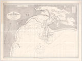
República Argentina, Puerto San Antonio, territorio del Río Negro / publicado por la Dirección General de Navegación y Comunicaciones del Ministerio de Marina
View
@ University of Wisconsin--Milwaukee

Description
4a edición 1929Relief shown by spot heights and hachures. Depths shown by bathymetric isolines and soundings.; Includes tidal and conversion tables and 6 buoy illustrations.; Selected lights shown in red.; "J. Noferi cart." -- lower right margin.; "6."Color1:50,000
Image
https://uwm.edu/libraries/digital-collections/copyright-digcoll/


")


![Map of New-York Bay and Harbor and the environs : [with colored manuscript additions to show positions of troops and fleets at the Battle of Long Island, 1776]](https://d2l9jrtx1kk04i.cloudfront.net/861b59bb0ac04500efd22c07eb61e9424fa0dae6.png "Map of New-York Bay and Harbor and the environs : [with colored manuscript additions to show positions of troops and fleets at the Battle of Long Island, 1776]")


