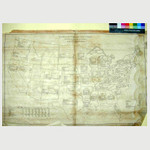
Wyld's military map of the United States, the northern states, and the southern confederate states: with the forts, harbours, arsenals, and military positions
View
@ Library of Congress
Description
London, 1861.Scale ca. 1:4,600,000. LC Civil War Maps (2nd ed.), 19 "Slave states" outlined in blue. Insets: City of Washington and District of Columbia. Scale ca. 1:190,000. 13 x 14 cm. Country round Washington. Scale ca. 1:1,020,000. 18 x 24 cm.-Pensacola bay and its fortifications. Scale ca. 1:155,000. 12 x 14 cm.-Charleston and the harbour. Scale ca. 1:132,000. 10 x 9 cm. Description derived from published bibliography. Available also through the Library of Congress web site as raster image.
Image
Map
Wyld, James, 1812-1887.
For rights relating to this resource, visit https://www.loc.gov/item/99447065/


![[Maps and diagrams of the Battle of Chickamauga, Ga. Sep 19 - 63] [Maps and diagrams of the Battle of Chickamauga, Ga. Sep 19 - 63]](https://d2l9jrtx1kk04i.cloudfront.net/1f72498d6134aff7f5cb5cb4d81d5c1cc6ec7882.png)


![[Major General William Starke Rosecrans of 23rd Ohio Infantry Regiment and General Staff U.S. Volunteers Infantry Regiment in uniform with telescope, map, and sword] [Major General William Starke Rosecrans of 23rd Ohio Infantry Regiment and General Staff U.S. Volunteers Infantry Regiment in uniform with telescope, map, and sword]](https://d2l9jrtx1kk04i.cloudfront.net/94f7f0b36f51331de9e52f5d00f09a67a4d4877a.png)


![[Map of Battlefield--gun and troop placement] [Map of Battlefield--gun and troop placement]](https://d2l9jrtx1kk04i.cloudfront.net/3015424fcd4a897a5b727809374c594d4dd6e332.png)

![[Map of battlefield] [Map of battlefield]](https://d2l9jrtx1kk04i.cloudfront.net/3c1bbfb70cc5148bbf83089e96d00020c1038eba.png)


